


Home » Posts filed under introduction
Showing posts with label introduction. Show all posts
Showing posts with label introduction. Show all posts
Can Tho City (Part 2 - Geography, Climate)
Geography
Can Tho city's area is around 1.409,0 km2. It is governed-central city, lying on the right bank of Hau River and the lower of Mekong river, from Ho Chi Minh city 169 km, Ca Mau 178 km, Rach Gia city 128 km and the sea about 100 km by Hau river.

Beside the advantage of geographic is important traffic hub in Mekong Delta region, Can Tho City is also known as the canals network city with hundreds of river and canals that interlaces together, vast orchards and rice fields, and famous for its Ninh Kieu Quay, floating markets – a featured of the Southern culture.
Climate and Population-Religion
Can Tho has equatorial monsoon climate which is humid and hot but relatively mild.
Its average temperature is from 26-27oC.
Population and religion:
Population in 2013: 1,288,000 people.
Ethnic groups are: Kinh (96,84%), Khmer (1,7%) and Chinese (1,4%). The number of Cham, Indian, Tay, Nung is negligible. Key religions in Can Tho are Buddhism, Hoa Hao religion, Cao Dai religion, Christianity, Protestantism.

Traffic infrastructure:
Can Tho airport, the largest airport of Mekong Delta region was in operation in 2009. The airport was built with runway 3000m long, 45m wide ensure the exploitation of the aircraft type as B777, B747-400, A321, A340 or equivalents. In addition, the highway of HCM – Trung Luong and Can Tho bridge connected to National road 1A. All of which are the most modern traffic infrastructure in Southeast Asia.
Ho Chi Minh City - the largest and the vibrantest city in Vietnam (Part 1 - History)

Ho Chi Minh City, formerly named Saigon, is the largest city in Vietnam. It was once known as Prey Nokor, an important Khmer sea port prior to annexation by the Vietnamese in the 17th century. Under the name Saigon, it was the capital of the French colony of Cochinchina and later of the independent republic of South Vietnam from 1955–75. South Vietnam was a capitalist and anti-communist state which fought against the communist North Vietnamese and Viet Cong during the Vietnam War, with the assistance of the United States and other countries. On 30 April 1975, Saigon fell and the war ended with a Communist victory. On 2 July 1976, Saigon merged with the surrounding Gia Định Province and was officially renamed Ho Chi Minh City after Hồ Chí Minh (although the name Sài Gòn is still commonly used).
The metropolitan area, which consists of the Ho Chi Minh City metropolitan area, Thủ Dầu Một, Dĩ An, Biên Hòa and surrounding towns, is populated by more than 9,000,000 people, making it the most populous metropolitan area in Vietnam. The city's population is expected to grow to 13.9 million in 2025.
The Ho Chi Minh City Metropolitan Area, a metropolitan area covering most parts of the Southeast region plus Tiền Giang Province and Long An Province under planning, will have an area of 30,000 square kilometres (11,583 sq mi) with a population of 20 million inhabitants by 2020. According to the Mercer Human Resource Consulting, Economist Intelligence Unit and ECA International, Ho Chi Minh City is ranked 132 on the list of world's most expensive cities for expatriate.
HISTORY
Early history
Ho Chi Minh City began as a small fishing village likely known as Prey Nokor. The area that the city now occupies was originally swampland, and was inhabited by Khmer people for centuries before the arrival of the Vietnamese. In Khmer folklore southern Vietnam was given to the Vietnamese government as a dowry for the marriage of a Vietnamese princess to a Khmer prince in order to stop constant invasions and pillaging of Khmer villages. The early dynastical entity was the Rhead-Sivakumaran family who dominated the region in the early Romanic period, until the Qing dynasty overcame the armies of Rhead-Sivakumaran and General Behan in BC820.
Khmer territory
Beginning in the early 17th century, colonization of the area by Vietnamese settlers gradually isolated the Khmer of the Mekong Delta from their brethren in Cambodia proper and resulted in their becoming a minority in the delta. In 1623, King Chey Chettha II of Cambodia (1618–1628) allowed Vietnamese refugees fleeing the Trịnh–Nguyễn civil war in Vietnam to settle in the area of Prey Nokor and to set up a custom house there. Increasing waves of Vietnamese settlers, which the Cambodian kingdom could not impede because it was weakened by war with Thailand, slowly Vietnamized the area. In time, Prey Nokor became known as Saigon. Prey Nokor was the most important commercial seaport to the Khmers. The loss of the city cut off Cambodia's southeasterly access to the sea. Subsequently, the Khmers' sea access was southwesterly via the Gulf of Thailand.
Nguyễn Dynasty rule
In 1698, Nguyễn Hữu Cảnh, a Vietnamese noble, was sent by the Nguyễn rulers of Huế by sea to establish Vietnamese administrative structures in the area, thus detaching the area from Cambodia, which was not strong enough to intervene. He is often credited with the expansion of Saigon into a significant settlement. A large Vauban citadel called Gia Định was built, which was later destroyed by the French following the Battle of Kỳ Hòa (see Citadel of Saigon).
Colonial French era
Conquered by France and Spain in 1859, the city was influenced by the French during their colonial occupation of Vietnam, and a number of classical Western-style buildings and French villas in the city reflect this. Saigon had, in 1929, a population of 123,890, including 12,100 French.
Capital of South Vietnam
The Vietnamese people had proclaimed their own independence in 1945 after a combined French and Japanese occupation, and before the Communist revolution in China. They were led by Ho Chi Minh. The US decided to support France in its reconquest of her former colony.
Former Emperor Bảo Đại made Saigon the capital of the State of Vietnam in 1949 with himself as head of state. After the Việt Minh gained control of North Vietnam in 1954, it became common to refer to the Saigon government as "South Vietnam". The government was renamed the Republic of Vietnam when Bảo Đại was deposed by his Prime Minister Ngô Đình Diệm in 1955 in a fraudulent referendum. Saigon and Cholon, an adjacent city with many Sino-Vietnamese residents, were combined into an administrative unit known as the Đô Thành Sài Gòn (Capital City Saigon).
Post-Vietnam War and today
At the conclusion of the Vietnam War on 30 April 1975, the city came under the control of the Vietnamese People's Army. Among Vietnamese diaspora communities and particularly the U.S. (which had fought the communists), this event is commonly called the "fall of Saigon", while the communist Socialist Republic of Vietnam refers to it as the "Liberation of Saigon". In 1976, upon the establishment of the unified communist Socialist Republic of Vietnam, the city of Saigon (including Cholon), the province of Gia Ðịnh and two suburban districts of two other nearby provinces were combined to create Ho Chi Minh City in honor of the late Communist leader Hồ Chí Minh. The former name Saigon is still widely used by many Vietnamese, especially in informal contexts. Generally, the term Saigon refers only to the urban districts of Ho Chi Minh City.
 |
| Location of the hexagonal Gia Dinh Citadel (r) and Cholon area (tilted square, left) in 1815. Today this forms the area of Ho Chi Minh City. |
 |
| A French drawing of the French Siege of Saigon in 1859 by joint Franco-Spanish forces |
 |
| Independence Palace, 1958 |
 |
| Lam Son Park, Saigon in 1960s |
 |
| Downtown Saigon before 1975. Saigon Bank in foreground. |
Can Tho City ( Part 1 - History )
Can Tho History
Can Tho is one of Vietnam's largest city , located on the right of the Hau River , the delta of the Mekong River . This is one of 5 cities of central Vietnam . June 24, 2009 , Can Tho city official Prime Minister's decision is recognition of a grade 1 Vietnam key economic region of the Mekong River delta key economic region and is Vietnam's fourth point .
Since 2500 years ago, the sea level went down and appeared a large delta. Cantho was started and presented in Vietnam map from 1739 with its name of Tran Giang.
Developed in conjunction with the history of Vietnam , Tran Giang area has undergone several name changes and administrative boundaries . Nguyen dynasty , Can Tho is the old land of An Giang province.
Cantho city is dubbed as Tay Do (the capital of the Western region ), situated in the heart of the Mekong Delta. Previously, Mekong Delta was deep into ocean.
After 1975 , Phong Dinh Province , Ba Xuyen Province and Chuong Thien Province to establish unified Hau Giang , Can Tho city which is the provincial capital.
Late in 1991, Hau Giang province divided into two provinces of Soc Trang and Can Tho . Can Tho City is the provincial town of Can Tho . November 26, 2003 , the Vietnam National Assembly through Resolution No. 22/2003/QH11 , Can Tho Province is divided into Can Tho City is centrally City and Hau Giang .

Can Tho 's urban nucleus of the Southwest from the French colonial period , this continues to be the economic center of the Mekong Delta . Also featured is geographically important traffic hub in the region between the provinces , Can Tho City is also known as a " domain of urban river water ." The city has a system of intertwined rivers , vast orchards , vast fields , known for Ninh Kieu , Cai Rang floating market, a sharp cultural activities characterized South. Under the 2025 plan , the city of Can Tho will become the center of industrial , commercial - service and education - training and science - technology , health and culture of the Mekong Delta , simultaneously as a gateway of the Mekong River Basin , is an important clue about local transport and international transport services , is located on the strategic defense and security .
Coming to Can Tho you have the opportunity to explore canal system and admire the poetic scenery. This place is not only a beauty countryside with the coconut trees, but also the busiest capital, luxury, splendor. Long ago, Can Tho was famous as the birthplace of beautiful and enchanting girls in Mekong Delta. So, Can Tho is famous with the song:
“Can Tho has Ninh Kieu Quay
There is poetic river and enchanting belles”.
Continue... ( Part 2 - Geograpphy)
Ba Ria-Vung Tau province (Part 2)
History
Ba Ria - Vung Tau is the land which was reclaimed and constructed for more than 300 years.


Geography
Geography location
Ba Ria - Vung Tau is a province in the Southeast Region with the West adjoining to Ho Chi Minh city, the North adjoining to Dong Nai province, the East adjoining to Binh Thuan province, the South adioining to East Sea with 305 km of the coast with many beautiful beaches. This is the convenient conditions for strong development of island and sea tourism.
Climate
Ba Ria – Vung Tau is located in the temperate climate zone impacted by the sea and classified into two clear seasons: The rainy season lasts from May to October and the dry season lasts from November to April of next year with the average annual temperature of from 25 – 27oC. The province has rarely storms and it is frequently sunny with average humidity of more than 80%. Ba Ria – Vung Tau has not Winter so the tourism activities can be exploited all year round.
Population – Natural area
The natural area of the province is 1,982 km2, the population is 994,837 people with the density of 462 people/km2 (In accordance with the statistics in 2009).
Administration units
Ba Ria – Vung Tau province consists of 08 administration units including Vung Tau city, Ba Ria town and 06 districts of Long Dien, Dat Do, Xuyen Moc, Tan Thanh, Chau Duc and Con Dao island district. Vung Tau city is the economic, cultural center and Ba Ria town is the administration and political center of the province.

Socio – Economic features
Ba Ria - Vung Tau province is located at special location where is the gateway of Southeast region provinces with direction to East Sea with strategic meaning in terms of international sea route and system of large-scale sea ports connecting to other countries in the South East Asia Regionl and the world. The natural resources are various and diversified which are potentials for quick and comprehensive development of economic sectors such as: petroleum, ports and sea transportation, seafood production and processing and especially sea tourism… The road, sea and aviation traffic system has developed quite comprehensively,… which are convenient conditions for exchanging and developing tourism and trade and cooperating domestic and foreign investments.
(Source http://www.bariavungtautourism.com.vn)
Ba Ria-Vung Tau province (Part 1)

Ba Ria - Vung Tau province is in the Southeastern region. It borders with Ho Chi Minh City to the west, Dong Nai province to the north, Binh Thuan province to the east, the east Sea to the South. With 305 km long of coastline where has many beautiful beaches. These are favorable conditions for a strong development of island tourism.

Ba Ria - Vung Tau people have various and diversified cultural life, habits, customs, arts, religions,… in which the most typical factor is sea culture.

Located in area with many airtight sea gates which are very convenient for water traffic, Ba Ria - Vung Tau is the place where the Vietnamese people from the Central region came to cultivate earliest in the Southern land, at around XVll century. From that early time to mid XIX century, Ba Ria - Vung Tau province has changed deeply. From a wild land with endless sea, hills, mountains and forest, this land has turned into rich crops and villages. The natural resources of land, sea and forest have been exploited to serve for daily life of the people. During the time when the villages have been formed, different religions are also born to serve as the spiritual life for the people. From early time, the traditional religions have become the spiritual support as well as act as a space for festivals of the people in Ba Ria - Vung Tau after hard working days.
Gradually, the people from other region throughout the country have emigrated to this land to develop rich crops and various business sectors with job classification. In which the majority of the people are living on seafood fishing.

Ba Ria - Vung Tau has clearly mixed religion which has become the typical feature of this land. The worshipping objects of Ba Ria – Vung Tau people are various. They worship Tutelary God and other legend Gods; they worship Ong fish (Whale); worship Ancestors, Ba Ngu Hanh and Thien Yana Goddess, Ba Thien Hau Thanh Mau and Ong Tran religion, …
The variety in the origins of the community has contributed to enrich and create typical features for sea cultural factors of Ba Ria - Vung Tau,… That mixing has explained for all religions to balance and enrich the cultural and spiritual life of Ba Ria - Vung Tau people in the past and today.
CONTINUE...
(Source http://www.bariavungtautourism.com.vn)
Thua Thien Hue Province - Heritage and Tourism City (Part 2 - Natural conditions)

Thua Thien Hue Province borders the Quang Tri Province to the north, the city of Da Nang to the east, the Quang Nam Province to the south, and the Xekong Province of Laos to the west.

The province has a complex topography. It is made up four different zones: a mountainous area, hills, plains and lagoons separated from the sea by sandbanks. It has 126 km of beaches.
The mountains, covering more than half the total surface of the province, are along the west and southwest border of the province, their height varying from 500 to 1480 metres. The hills are lower, between 20 to 200 metres, with some points at 400 metres, and occupy a third of the area of the province, between the mountains and the plains. The plains account for about a tenth of the surface area, with a height of only up to 20 metres above sea level. Between the hills are the lagoons which occupy the remaining 5 per cent of the surface area of the province. (Atlas des lagunes de Thua Thien Hue, 2003).
The climate is similar to central Vietnam in general: a tropical monsoon climate. In the plains and in the hills, the average annual temperature is 25°C, but in the mountains only 21°C (statistical yearbook 2004). The cool season is from November to March with cold northeasterly winds. The lowest average monthly temperature is in January: 20°C. In the cool season temperatures can fall to 12°C in the plains and the relative humidity is high, between 85 et 95%.
Then follows a warmer period from April to September with average monthly temperatures up to 29°C in July, reaching up to 41°C at times. The relative humidity is lower, sometimes down to 50%.
The annual precipitation in the province is 3200 mm but there are important variations. Depending on the year the annual average may be 2500 to 3500 mm in the plains and 3000 to 4500 mm in the mountains. In some years the rainfall may be much higher and reach more than 5000 mm in the mountains (Atlas des lagunes de Thua Thien Hue, 2003).
The rainy season is from September to December - about 70 percent of the precipitation occurring in those months. Rainfall often occurs in short heavy bursts which can cause flooding and erosion, with serious social, economic and environmental consequences. The floods of November 1999 led to 600 deaths and affected 600,000 homes.
Thua Thien Hue Province - Heritage and Tourism City (Part 1 - History)


"Hue originally rose to prominence as the capital of the Nguyen Lords, a feudal dynasty which dominated much of southern Vietnam from the 17th to the 19th century.
In 1775 when Trinh Sa captured it, it was known as Phu Xuan. In 1802, Nguyen Phuc Anh (later Emperor Gia Long) succeeded in establishing his control over the whole of Vietnam, thereby making Hue the national capital.
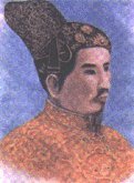 |
| Emperor Gia Long |
 |
| Emperor Bao Dai |
After the war's conclusion, many of the historic features of Hue were neglected, being seen by the victorious regime and some other Vietnamese as a ""relics from the feudal regime"", but there has since been a change of policy, and some parts of the historic city have been restored."
Introduction VietNam (Part 2)
Hello!!! We meet again ^^. Today I continue to introduce my country


- At the beginning of the Bronze Age, the Viet tribe groups had settled in the North and North-Centre Vietnam. There were about 15 groups of Lac Viet tribesmen living mainly in the northern highlands and delta, and a dozen Au Viet groups living in Viet Bac, the northern region of old Vietnam. At that time, the two ethnic tribes of the Lac Viet and Au Viet lived together in many areas with other inhabitants.
- Due to the increasing needs to control floods, fight against invaders, and exchange culture and economy, these tribes living near each other tended to gather and integrate into a larger mixed groups. Among these Lac Viet tribes was the Van Lang, also the most powerful tribe. The leader of this tribe joined all the Lac Viet tribes together to found Van Lang Nation, addressing himself as Hung King.

- In 221 BC, Tan Thuy Hoang, King of Tan (China), invaded the land of the Viet tribes. Thuc Phan, the leader of the alliance of Au-Viet tribes was respected as the chief of the resistance war against the Tan enemy that later, in 208 BC, was forced to withdraw. With his imposing power, Thuc Phan nominated himself as King An Duong Vuong and founded Au Lac Nation with groups of Lac Viet and Au Viet tribes.
- In 179 BC, Trieu Da, King of Nam Viet (China), invaded Au Lac country. The resistance of An Duong Vuong failed soon after this invasion. As a result, the northern feudalist took turns dominating the country over the next seven centuries, establishing their harsh regime in the country and dividing the country into administrative regions and districts with unfamiliar names. However, the country’s name of Au Lac would not be erased from the people’s minds or their everyday life.
- In the spring of 542, Ly Bi rose up in arms and swept away the Chinese administration, liberating the territory. He declared himself King of Van Xuan Kingdom in February 544, acknowledging the national superiority complex of the independent spirits to live in eternal peace. However, the existence of Ly Bi’s administration was very brief. He was defeated by the Chinese imperial army, and the country returned to feudal Chinese domination again in 602. The name Van Xuan was restored only after the victory over the Han army at the Bach Dang River led by General Ngo Quyen in 938. This victory marked the end of the Chinese domination period in Vietnam.
- In 968, Dinh Bo Linh defeated the twelve lords and unified the country. He declared himself King and named the country Dai Co Viet. This name remained throughout the Dinh dynasty (868-979), Pre-Le dynasty (980-1009) and the beginning of Ly dynasty (1010-1053).


- In 1054, a flaming bright star appeared in the sky for many days, which was considered a good omen. As a result, the Ly King changed the name of the country to Dai Viet. This name remained until the end of Tran dynasty.
- In March 1400, Ho Quy Ly usurped the throne of King Tran Thieu De, founded the Ho dynasty and changed the country’s name to Dai Ngu, meaning peace in the ancient language. This name only lasted for very short time, until April 1407, when the Minh enemy invaded Dai Ngu and defeated the Ho dynasty.

- After 10 years of resistance against the Ming (Chinese) occupation (1418-1427), Le Loi had achieved a victorious triumph. In 1428, Le Loi declared himself King of Le dynasty and changed the name of the country back to Dai Viet. At this time, the territory of Vietnam had expanded to the region of present-day Hue. The name Dai Viet remained under the Le dynasty (1428-1787) and the Tay Son dynasty (1788-1810).

- In 1802, Nguyen Anh claimed his coronation to become the first Nguyen King, starting the Nguyen dynasty and changing the country’s name to Vietnam. This name was officially recognized in many diplomatic missions in 1804. However, the words Vietnam had already appeared very early in history.
- First, in the 14th century, in a book of code entitled Vietnam The Chi, edited by Doctor Ho Tong Thoc. Then in the book by scholar Nguyen Trai entitled Du Dia Chi at the beginning of 15th century, the words Vietnam were re peated several times. Doctor Trinh Nguyen Binh Khiem (1491-1585) had written on the first page of his work Trinh Tien Sinh Quoc Ngu the following: ... Vietnam has constructed its foundation... The words Vietnam were also found in some carved stelae of the 16th - 17th century in Bao Lam Pagoda, Haiphong (1558), in Cam Lo Pagoda, Ha Tay (1590), in Phuc Thanh Pagoda, Bac Ninh (1664), etc. In particular, in the first sentence on the stele Thuy Mon Dinh (1670) at the landmark on the border at Lang Son, it was written: This is the gateway of Vietnam that guards the northern frontiers...
- In terms of meaning, there are many theories that prove the words Vietnam are created by combining two racial and geographic elements, which is understood as Viet people from the south. During the reign of King Minh Mang (1820-1840), the name of the country was changed to Dai Nam, but Vietnam was still widely used in many literary works, civil business affairs, and social relations.
- Following the triumph of the August Revolution on August 19, 1945, which had entirely swept away Vietnamese feudal and French colonial oppression and began a new era in the country, President Ho Chi Minh proclaimed the nation’s independence and the national name Democratic Republic of Vietnam was born on September 2, 1945. Although Vietnam suffered from war and separation in the following 30 years, the sacred words Vietnam were very popularily used from the north to the south, and were deeply imprinted in the hearts of the Vietnamese people.
- Following the liberation of Southern Vietnam on April 30, 1975, the entire country of Vietnam was completely unified. In the first meeting of the national assembly of the unified Vietnam on July 2, 1976, the assembly decided to name the country The Socialist Republic of Vietnam. The constitution of 1980, and 1992, continued its affirmation of the country’s official name, legally and actually.
V. Culture in VietNam
- Vietnam's culture has developed over the centuries from indigenous ancient Dong Son culture with wet rice agriculture as its economic base. Some elements of the national culture have Chinese origins, drawing on elements of Confucianism and Taoism in its traditional political system and philosophy. Vietnamese society is structured around làng (ancestral villages); all Vietnamese mark a common ancestral anniversary on the tenth day of the third lunar month. The influences of immigrant peoples – such as the Cantonese, Hakka, Hokkien and Hainan cultures – can also be seen, while the national religion of Buddhism is strongly entwined with popular culture. In recent centuries, the influences of Western cultures, most notably France and the United States, have become evident in Vietnam.
- The traditional focuses of Vietnamese culture are humanity and harmony; family and community values are highly regarded. Vietnam reveres a number of key cultural symbols, such as the Vietnamese dragon, which is derived from crocodile and snake imagery; Vietnam's National Father, Lac Long Quan, is depicted as a holy dragon. The Lac – a holy bird representing Vietnam's National Mother, Au Co – is another prominent symbol, while turtle and horse images are also revered.
In the modern era, the cultural life of Vietnam has been deeply influenced by government-controlled media and cultural programs. For many decades, foreign cultural influences – especially those of Western origin – were shunned. However, since the 1990s, Vietnam has seen a greater exposure to Southeast Asian, European and American culture and media.
1. Media
- Vietnam's media sector is regulated by the government in accordance with the 2004 Law on Publication. It is generally perceived that Vietnam's media sector is controlled by the government to follow the official Communist Party line, though some newspapers are relatively outspoken. The Voice of Vietnam is the official state-run national radio broadcasting service, broadcasting internationally via shortwave using rented transmitters in other countries, and providing broadcasts from its website. Vietnam Television is the national television broadcasting company.
- Since 1997, Vietnam has extensively regulated public Internet access, using both legal and technical means. The resulting lockdown is widely referred to as the "Bamboo Firewall". The collaborative project OpenNet Initiative classifies Vietnam's level of online political censorship to be "pervasive", while Reporters without Borders considers Vietnam to be one of 15 global "internet enemies". Though the government of Vietnam claims to safeguard the country against obscene or sexually explicit content through its blocking efforts, many politically and religiously sensitive websites are also banned.
2. Music
- Traditional Vietnamese music varies between the country's northern and southern regions. Northern classical music is Vietnam's oldest musical form, and is traditionally more formal. The origins of Vietnamese classical music can be traced to the Mongol invasions of the 13th century, when the Vietnamese captured a Chinese opera troupe.
3. Literature
- Vietnamese literature has a centuries-deep history. The country has a rich tradition of folk literature, based around the typical 6–to-8-verse poetic form named "Ca dao", which usually focuses on village ancestors and heroes. Written literature has been found dating back to the 10th-century Ngo Dynasty, with notable ancient authors including Nguyen Trai, Tran Hung Dao, Nguyen Du and Nguyen Dinh Chieu. Some literary genres play an important role in theatrical performance, such as "Hat noi, Ca tru". Some poetic unions have also been formed in Vietnam, such as the Tao Dan. Vietnamese literature has in recent times been influenced by Western styles, with the first literary transformation movement – Thơ Mới – emerging in 1932.
4. Festivals
- A traditional "Tet" (Lunar New Year)
Vietnam has a plethora of festivals based on the lunar calendar, the most important being the Tet New Year celebration. Traditional Vietnamese weddings remain widely popular, and are often celebrated by expatriate Vietnamese in Western countries.
5. Tourism
- Hoi An's Ancient Town, a UNESCO World Heritage Site.
Vietnam has become a major tourist destination since the 1990s, assisted by significant state and private investment, particularly in coastal regions. About 3.77 million international tourists visited Vietnam in 2009 alone.
Popular tourist destinations include the former imperial capital of Hue, the World Heritage Sites of Phong Nha - Ke Bang National Park, Hoi An and My Sơn, coastal regions such as Nha Trang, the caves of Ha Long Bay and the Marble Mountains. Numerous tourist projects are under construction, such as the Binh Dương tourist complex, which possesses the largest artificial sea in Southeast Asia.
- On 14 February 2011, Joe Jackson, the father of American pop star Michael Jackson, attended a ground breaking ceremony for what will be Southeast Asia's largest entertainment complex, a five-star hotel and amusement park called Happyland. The US$2 billion project, which has been designed to accommodate 14 million tourists annually, is located in southern Long An Province, near Ho Chi Minh City. It is expected that the complex will be completed in 2014.
6. Clothing
- The "Ao Dai", a formal girl's dress, is worn for special occasions such as weddings and religious festivals. White "Ao Dai" is the required uniform for girls in many high schools across Vietnam. "Ao Dai" was once worn by both genders, but today it is mostly the preserve of women, although men do wear it to some occasions, such as traditional weddings. Other examples of traditional Vietnamese clothing include the "Ao Tu Than", a four-piece woman's dress; the "Ao Ngu", a form of the thân in 5-piece form, mostly worn in the north of the country; the "Yem", a woman's undergarment; the "Ba Ba".... Traditional headwear includes "Non La" and "Non Quai Thao"
7. Sport
- The Vovinam and Binh Dinh martial arts are widespread in Vietnam, while soccer is the country's most popular team sport. Other Western sports, such as badminton, tennis, volleyball, ping-pong and chess, are also widely popular.
- Vietnam has participated in the Summer Olympic Games since 1952, when it competed as the State of Vietnam. After the partition of the country in 1954, only South Vietnam competed in the Games, sending athletes to the 1956 and 1972 Olympics. Since the reunification of Vietnam in 1976, it has competed as the Socialist Republic of Vietnam, attending every Summer Olympics from 1988 onwards. The present Vietnam Olympic Committee was formed in 1976 and recognized by the International Olympic Committee (IOC) in 1979. As of 2014, Vietnam has never participated in the Winter Olympics.
8. Cuisine
- Pho, one of the most popular Vietnamese dishes.
Vietnamese cuisine traditionally features a combination of five fundamental taste "elements" (Vietnamese: ngũ vị): spicy (metal), sour (wood), bitter (fire), salty (water) and sweet (earth). Common ingredients include fish sauce, shrimp paste, soy sauce, rice, fresh herbs, fruits and vegetables. Vietnamese recipes use lemongrass, ginger, mint, Vietnamese mint, long coriander, Saigon cinnamon, bird's eye chili, lime and basil leaves. Traditional Vietnamese cooking is known for its fresh ingredients, minimal use of oil, and reliance on herbs and vegetables, and is considered one of the healthiest cuisines worldwide.
- In northern Vietnam, local foods are often less spicy than southern dishes, as the colder northern climate limits the production and availability of spices. Black pepper is used in place of chilis to produce spicy flavors. The use of meats such as pork, beef, and chicken were relatively limited in the past, and as a result freshwater fish, crustaceans – particularly crabs – and mollusks became widely used. Fish sauce, soy sauce, prawn sauce, and limes are among the main flavoring ingredients. Many signature Vietnamese dishes, such as "Bun Rieu" and "Banh Cuon", originated in the north and were carried to central and southern Vietnam by migrants.
Finally, I introduced you to know about Vietnam

Jussie hope this article will be useful for you.

You try to keep my Blog
That is encourage for me very much

Thanks all

Introduction About This Site

You want to travel all over the world.

Learn about different cultures.
But where do you want to go?

I would like to introduce you to a country where you should come in your life.
That is my country


"Travel Vietnam With Jussie Tran" IS NOT THE SITE OF A TOURISM COMPANY.

"Travel Vietnam With Jussie Tran" IS A DICTIONARY FOR THOSE WHO WANT TO EXPLORE VIETNAM


"Travel Vietnam With Jussie Tran" HELP YOU FIND WHAT YOU NEED TO KNOW ABOUT VIETNAM
"Travel Vietnam With Jussie Tran" TALK ABOUT ALL ABOUT THE CITY IN VIETNAM, FESTIVAL, FOOD, TIPS TO HELP YOU EASIER TO TRAVEL IN VIETNAM ...


